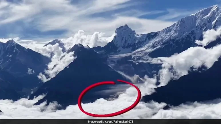
A dramatic drone video has captured the moment a massive section of glacier and rock collapsed in the Himalayas, providing striking visual evidence of the event that triggered the devastating Nepal-Tibet flash floods on August 26. The footage, recorded accidentally by a Chinese photographer, shows an enormous mass breaking away from the mountain near the Langtang Lirung peak.
The footage is significant because it offers a rare visual account of what happened high in the mountains before floodwaters and debris swept through valleys below. Videos captured by tourists and hikers show the collapse occurring shortly after loud cracking and rumbling sounds were heard in the region.
What the Drone Footage Reveals
The newly surfaced footage shows a huge section of ice and bedrock breaking away from the mountain slope before disappearing into a cloud of dust and debris. The collapse occurred near the Langtang Lirung region, close to the Nepal-China border.
The event was not simply a conventional landslide. Scientists examining satellite imagery and other evidence have indicated that the failure of bedrock beneath a glacier caused a major rock-and-ice collapse. The resulting debris and meltwater rapidly entered river systems, dramatically increasing the volume and force of the floodwaters.
This explains why the flooding was so sudden and destructive. Communities downstream had very little time to react as water, mud, rocks and ice moved rapidly through the valleys.
Why This Matters
The drone footage could help scientists better understand the sequence of events that produced one of the region’s worst recent disasters. Images taken before and after the collapse provide an opportunity to compare the mountain landscape and identify how much ice and rock came down the slope.
The disaster has also highlighted the growing importance of early-warning systems in the Himalayas. A collapse at high altitude can transform into a devastating flood within minutes, leaving communities downstream with almost no evacuation window.
The human cost has been enormous. Current reports put the combined death toll in Nepal and Tibet at more than 900, while thousands remain missing. Rescue teams continue to search devastated communities and hydropower facilities for survivors.
A Warning for the Himalayan Region
The disaster raises wider questions about how Himalayan communities can prepare for rapidly developing glacier-related hazards. Monitoring glaciers, unstable slopes and glacial lakes is becoming increasingly important as mountain environments undergo significant changes.
The latest drone footage does more than show a spectacular natural event. It provides a visual link between the glacier collapse and the catastrophic flooding that followed, helping explain how a disaster that began high in the mountains quickly became a cross-border humanitarian crisis.
For Nepal and neighbouring regions, the lesson is clear: better monitoring, faster warnings and stronger disaster-response systems could be critical in reducing the human cost of future Himalayan disasters.